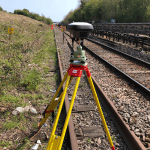
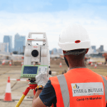
General

  1. Surveying existing water features with the Leica GS18 T RTK Rover

    Surveying existing water features with the Leica GS18 T RTK Rover
    Located centrally on the South Coast and covering the UK D G Yeatman Surveying & Engineering Ltd have over 36 years experience in all aspects of surveying including topographic, hydrographical, volumetric, as-built, monitoring and building. Providing a high level of service to clients as diverse as local builders to multinationals and local authorities. A recent project Darren Yeatman and his...
  2. Webinar: Introduction to the BLK360, capturing 3D reality at the push of a button

    Webinar: Introduction to the BLK360, capturing 3D reality at the push of a button
    The Leica BLK360 defines a new product category of its own: the laser imaging scanner. It is so small and light that it fits in a briefcase and can be carried almost anywhere. It has a measuring range of 60 meters for full captures. To get an idea, a full laser scan, 3D panoramic image capture, thermal imaging and transfer...
  3. Utilities and Detection Training Courses

    Utilities and Detection Training Courses
    At SCCS we understand the importance of training and professional development of you and your staff. With the increased rate at which the building and construction of infrastructure is taking place in the UK, it's essential to stay up to stay up-to-date and look after your workforce. Leica Geosystems take pride in delivering quality, without compromise, Cable Avoidance training. As...
  4. Measure What You See

    Measure What You See
    Get ready for the imaging power of GNSS that will help you measure hundreds of points in minutes across any obstruction. #MeasureWhatYouSee
  5. The full laser scan survey of a Grade II* Listed historic building

    The full laser scan survey of a Grade II* Listed historic building
    Ridge and Partners LLP is a multidiscipline Property and Construction Consultancy with over 650 employees working worldwide from 11 offices across the UK. In September 2019 their Geospatial team were commissioned by Oxford City Council to undertake a full laser scan survey and produce a Revit 3D Model of the Oxford Town Hall, a grade II* listed building in the...

Items 16 to 20 of 214 total