SCS Railways is a joint venture (JV) bringing together Skanska, Costain and STRABAG (SCS), an industry-leading partnership of global high-speed rail expertise and knowledge.
 This JV has a proven record in delivering major infrastructure, high-speed rail and some of the most iconic structures across the globe. A 30-year history of successful civil engineering projects has been delivered by Skanska and Costain including the M25, High Speed 1 and Crossrail. STRABAG and Skanska have worked collectively for over 15 years on projects in Norway, Slovakia and Switzerland.
High Speed 2 (HS2) is a new state-of-the-art high-speed railway and will be the second major high-speed rail line in Britain. When completed the much-needed rail capacity will link London, Birmingham, Manchester and Leeds with a network of 360 km/h (225 mph) tracks.
One of the sections currently in construction is the route between Euston and West Ruislip for which SCS JV is the main contractor. They are responsible for 17 works and compounds across of the two southern sections of HS2 (S1 & S2).
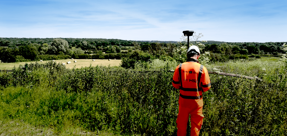
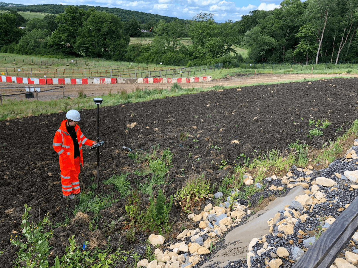
In November 2019, Tom Emerson, Senior Engineering Surveyor at SCS Railways and his team of surveyors started utilising multiple Leica GS18 T GNSS RTK Rovers to measure and stakeout points for earthworks which preceed the construction of tunnelling, together with shafts, portals and boxes.
This JV has a proven record in delivering major infrastructure, high-speed rail and some of the most iconic structures across the globe. A 30-year history of successful civil engineering projects has been delivered by Skanska and Costain including the M25, High Speed 1 and Crossrail. STRABAG and Skanska have worked collectively for over 15 years on projects in Norway, Slovakia and Switzerland.
High Speed 2 (HS2) is a new state-of-the-art high-speed railway and will be the second major high-speed rail line in Britain. When completed the much-needed rail capacity will link London, Birmingham, Manchester and Leeds with a network of 360 km/h (225 mph) tracks.
One of the sections currently in construction is the route between Euston and West Ruislip for which SCS JV is the main contractor. They are responsible for 17 works and compounds across of the two southern sections of HS2 (S1 & S2).
In November 2019, Tom Emerson, Senior Engineering Surveyor at SCS Railways and his team of surveyors started utilising multiple Leica GS18 T GNSS RTK Rovers to measure and stakeout points for earthworks which preceed the construction of tunnelling, together with shafts, portals and boxes.
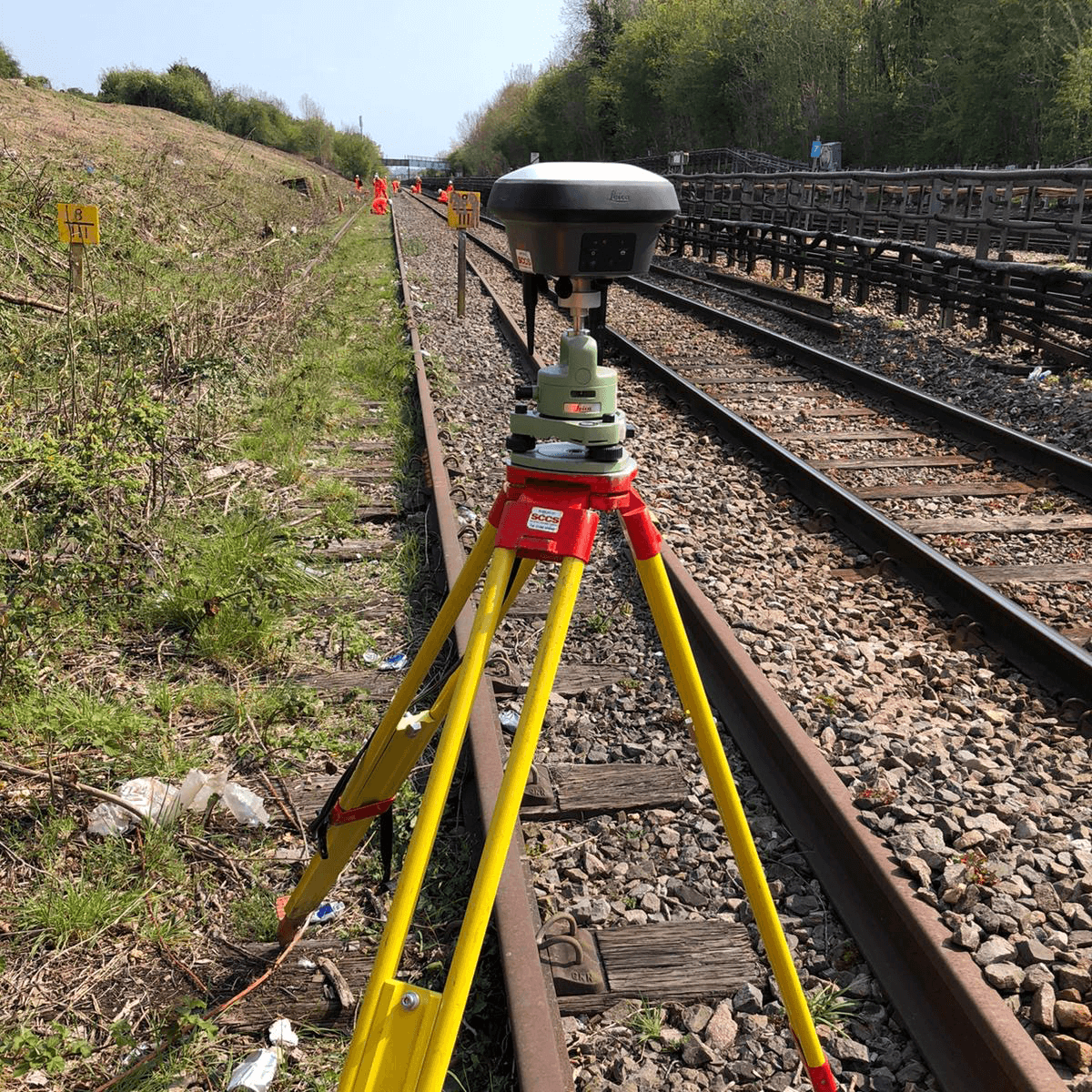 Leica GS18 T GNSS with Smartnet NRTK
SCS Railways chose to use the Leica GS18 T GNSS with Smartnet NRTK over Mobile Network due to the intuitive nature of the Leica Captivate operating system and impressive tilt function. They found the Leica GS18 T to be, without doubt, the fastest, most accurate and easiest GNSS smart antenna and RTK rover to use. One of the reasons this instrument was chosen was the tilt compensation solution, which is achieved by connecting the GNSS and inertial measuring units (IMUs). New users found it easy to use on-site and made great use of the tilt function which helped the teams carry out their survey and setting out work with increased speed and efficiency and without having to check the bubble. It also allowed them to check survey control when a tripod set up was on it or it had an obstruction.
Leica GS18 T GNSS with Smartnet NRTK
SCS Railways chose to use the Leica GS18 T GNSS with Smartnet NRTK over Mobile Network due to the intuitive nature of the Leica Captivate operating system and impressive tilt function. They found the Leica GS18 T to be, without doubt, the fastest, most accurate and easiest GNSS smart antenna and RTK rover to use. One of the reasons this instrument was chosen was the tilt compensation solution, which is achieved by connecting the GNSS and inertial measuring units (IMUs). New users found it easy to use on-site and made great use of the tilt function which helped the teams carry out their survey and setting out work with increased speed and efficiency and without having to check the bubble. It also allowed them to check survey control when a tripod set up was on it or it had an obstruction.
 At this early stage in the project, the GNSS solution was the best and realistically the only viable choice. It provided dimensional control to site engineers at a time when it was safe and most applicable. With the increased volume of heavy plant movement over the ground, it meant it was unpractical from both a safety and ground disturbance perspective to use a total station with a traversed control network.
One hurdle SCS Railways had to overcome on a project such as this were multiple engineers with varying levels of experience and in different locations. Unbeknown to many of the engineers on the ground, the HS2 project grid had recently been updated to reflect the Ordnance Survey’s OSTN15 and OSGM15 transformation, so out of date geoid models would have continued to be used.
Because of updates to the underlying GNSS reference frame in the UK which were applied by the Ordnance Survey in 2016, the original HS2 SnakeGrid coordinate transformation used to generate HS2 Survey Grid Eastings and Northings now returns incorrect values around 1-2cm in magnitude. A similar issue was encountered when the height reference frame changed from OSGM02 to OSGM15, with height errors of 2-3cm. So, the HS2 organisation have now published new transformation files which will return correct Easting, Northing and height values when used with GNSS equipment. Leica Geosystems remained closely involved with HS2 during the development of these new files, and ALL Leica Geosystems GNSS sensors and software (including Mobile mapping, UAV and Machine Control systems) seamlessly use the updated files for correct positioning within HS2 Survey Grid 2015.
SCCS Survey Equipment supplied the Leica GS18 T kits with the HS2 coordinate system pre-loaded and because of this preinstallation it minimised any confusion with loading a new coordinate system which in turn avoided any conversions. The GS18 T was simply put on a control point for a coordinate check and the team went off to work without delay.
The SCS Railways team used various survey methods which included rapid static GNSS control, topographic survey and staking out of points and lines for the installation of new compounds across the job and made use of all the increased efficiencies the Leica GS18T provided.
“The Leica GS18 T was the perfect instrument for the work we required. SCCS, who supplied the equipment, visited us on-site to support with coordinate system import and gave great training specific to this project.”
Tom Emerson, Snr Engineering Surveyor SCS Railways
At this early stage in the project, the GNSS solution was the best and realistically the only viable choice. It provided dimensional control to site engineers at a time when it was safe and most applicable. With the increased volume of heavy plant movement over the ground, it meant it was unpractical from both a safety and ground disturbance perspective to use a total station with a traversed control network.
One hurdle SCS Railways had to overcome on a project such as this were multiple engineers with varying levels of experience and in different locations. Unbeknown to many of the engineers on the ground, the HS2 project grid had recently been updated to reflect the Ordnance Survey’s OSTN15 and OSGM15 transformation, so out of date geoid models would have continued to be used.
Because of updates to the underlying GNSS reference frame in the UK which were applied by the Ordnance Survey in 2016, the original HS2 SnakeGrid coordinate transformation used to generate HS2 Survey Grid Eastings and Northings now returns incorrect values around 1-2cm in magnitude. A similar issue was encountered when the height reference frame changed from OSGM02 to OSGM15, with height errors of 2-3cm. So, the HS2 organisation have now published new transformation files which will return correct Easting, Northing and height values when used with GNSS equipment. Leica Geosystems remained closely involved with HS2 during the development of these new files, and ALL Leica Geosystems GNSS sensors and software (including Mobile mapping, UAV and Machine Control systems) seamlessly use the updated files for correct positioning within HS2 Survey Grid 2015.
SCCS Survey Equipment supplied the Leica GS18 T kits with the HS2 coordinate system pre-loaded and because of this preinstallation it minimised any confusion with loading a new coordinate system which in turn avoided any conversions. The GS18 T was simply put on a control point for a coordinate check and the team went off to work without delay.
The SCS Railways team used various survey methods which included rapid static GNSS control, topographic survey and staking out of points and lines for the installation of new compounds across the job and made use of all the increased efficiencies the Leica GS18T provided.
“The Leica GS18 T was the perfect instrument for the work we required. SCCS, who supplied the equipment, visited us on-site to support with coordinate system import and gave great training specific to this project.”
Tom Emerson, Snr Engineering Surveyor SCS Railways
 SCS Railways
https://www.scsrailways.co.uk/
Download the Case Study PDF
SCS Railways
https://www.scsrailways.co.uk/
Download the Case Study PDF
Compare the full range of Leica Geosystems GNSS Smart Antennas here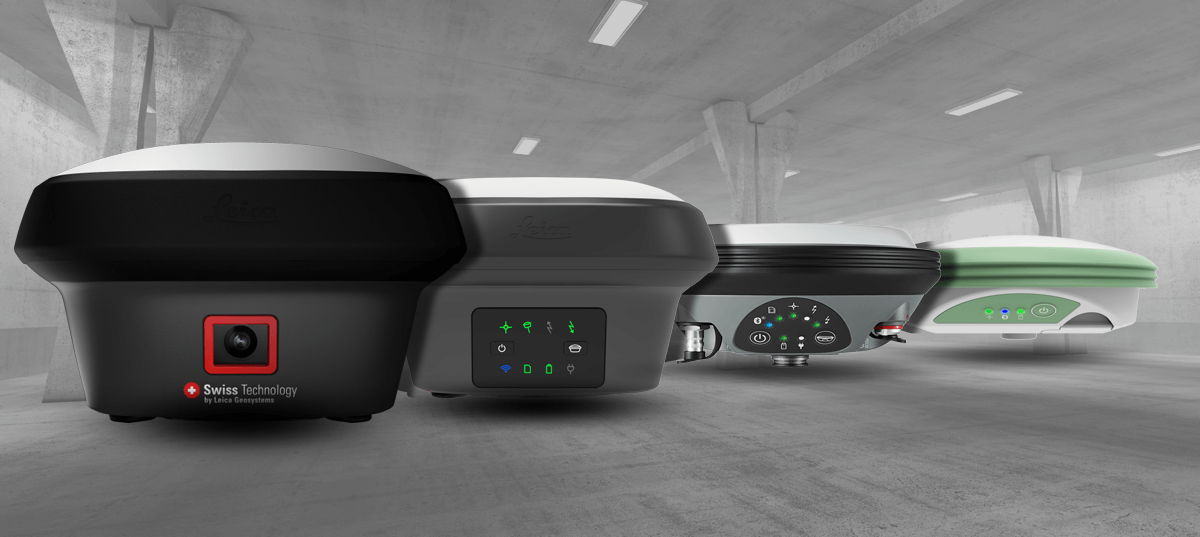
SCCS is a flagship business for both the hire and sale of surveying equipment, providing the highest level of service to the civil engineering, surveying and construction industries. Our ethos is to provide the highest level of service and support, always put our customers first and establish long term relationships across the industry. SCCS, part of Hexagon, is the leading provider of technologically advanced surveying hardware and software equipment together with solutions for positioning and measuring in the UK. SCCS - The Survey Equipment Company www.sccssurvey.co.uk sales@sccssurvey.co.uk Tel: 01480 404888
This JV has a proven record in delivering major infrastructure, high-speed rail and some of the most iconic structures across the globe. A 30-year history of successful civil engineering projects has been delivered by Skanska and Costain including the M25, High Speed 1 and Crossrail. STRABAG and Skanska have worked collectively for over 15 years on projects in Norway, Slovakia and Switzerland.
High Speed 2 (HS2) is a new state-of-the-art high-speed railway and will be the second major high-speed rail line in Britain. When completed the much-needed rail capacity will link London, Birmingham, Manchester and Leeds with a network of 360 km/h (225 mph) tracks.
One of the sections currently in construction is the route between Euston and West Ruislip for which SCS JV is the main contractor. They are responsible for 17 works and compounds across of the two southern sections of HS2 (S1 & S2).
In November 2019, Tom Emerson, Senior Engineering Surveyor at SCS Railways and his team of surveyors started utilising multiple Leica GS18 T GNSS RTK Rovers to measure and stakeout points for earthworks which preceed the construction of tunnelling, together with shafts, portals and boxes.
Leica GS18 T GNSS with Smartnet NRTK
SCS Railways chose to use the Leica GS18 T GNSS with Smartnet NRTK over Mobile Network due to the intuitive nature of the Leica Captivate operating system and impressive tilt function. They found the Leica GS18 T to be, without doubt, the fastest, most accurate and easiest GNSS smart antenna and RTK rover to use. One of the reasons this instrument was chosen was the tilt compensation solution, which is achieved by connecting the GNSS and inertial measuring units (IMUs). New users found it easy to use on-site and made great use of the tilt function which helped the teams carry out their survey and setting out work with increased speed and efficiency and without having to check the bubble. It also allowed them to check survey control when a tripod set up was on it or it had an obstruction.
At this early stage in the project, the GNSS solution was the best and realistically the only viable choice. It provided dimensional control to site engineers at a time when it was safe and most applicable. With the increased volume of heavy plant movement over the ground, it meant it was unpractical from both a safety and ground disturbance perspective to use a total station with a traversed control network.
One hurdle SCS Railways had to overcome on a project such as this were multiple engineers with varying levels of experience and in different locations. Unbeknown to many of the engineers on the ground, the HS2 project grid had recently been updated to reflect the Ordnance Survey’s OSTN15 and OSGM15 transformation, so out of date geoid models would have continued to be used.
Because of updates to the underlying GNSS reference frame in the UK which were applied by the Ordnance Survey in 2016, the original HS2 SnakeGrid coordinate transformation used to generate HS2 Survey Grid Eastings and Northings now returns incorrect values around 1-2cm in magnitude. A similar issue was encountered when the height reference frame changed from OSGM02 to OSGM15, with height errors of 2-3cm. So, the HS2 organisation have now published new transformation files which will return correct Easting, Northing and height values when used with GNSS equipment. Leica Geosystems remained closely involved with HS2 during the development of these new files, and ALL Leica Geosystems GNSS sensors and software (including Mobile mapping, UAV and Machine Control systems) seamlessly use the updated files for correct positioning within HS2 Survey Grid 2015.
SCCS Survey Equipment supplied the Leica GS18 T kits with the HS2 coordinate system pre-loaded and because of this preinstallation it minimised any confusion with loading a new coordinate system which in turn avoided any conversions. The GS18 T was simply put on a control point for a coordinate check and the team went off to work without delay.
The SCS Railways team used various survey methods which included rapid static GNSS control, topographic survey and staking out of points and lines for the installation of new compounds across the job and made use of all the increased efficiencies the Leica GS18T provided.
“The Leica GS18 T was the perfect instrument for the work we required. SCCS, who supplied the equipment, visited us on-site to support with coordinate system import and gave great training specific to this project.”
Tom Emerson, Snr Engineering Surveyor SCS Railways
Compare the full range of Leica Geosystems GNSS Smart Antennas here
SCCS is a flagship business for both the hire and sale of surveying equipment, providing the highest level of service to the civil engineering, surveying and construction industries. Our ethos is to provide the highest level of service and support, always put our customers first and establish long term relationships across the industry. SCCS, part of Hexagon, is the leading provider of technologically advanced surveying hardware and software equipment together with solutions for positioning and measuring in the UK. SCCS - The Survey Equipment Company www.sccssurvey.co.uk sales@sccssurvey.co.uk Tel: 01480 404888