From their offices in Macclesfield and Romiley, ScanTech International is an engineering site survey consultancy providing accurate as-built data within the built environment across a broad spectrum of market sectors.
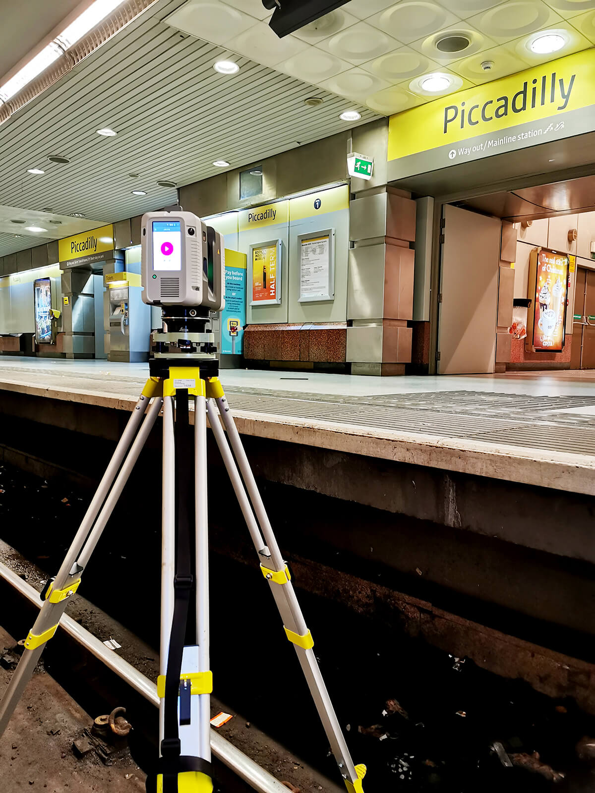
 ScanTech was one of the first companies in the UK to purchase a portable laser scanner, the Leica HDS 2500 in 2002, which at the time was state of the art capturing 1,200 points per second over a 40° x 40° field of view and taking 20 minutes per scan. They then upgraded to the much-improved Leica RTC360 Laser Scanner now captures 2,000,000 points per second with a 360° x 310° field of view and takes just 30 seconds per scan.
 The expertise and knowledge ScanTech have developed over the years now provides them unrivalled abilities and techniques such as capturing the inside running edge of rails – a difficult task as it is a virtual position.
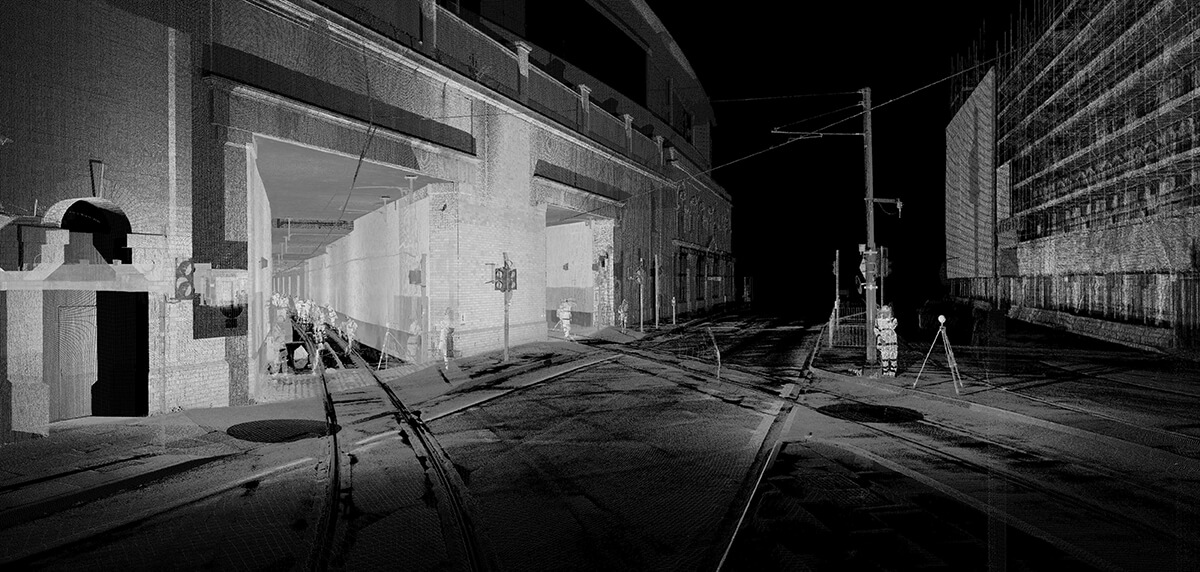
Recently, ScanTech were required to produce the 3D survey Jetstream files of the Manchester Piccadilly Metro Station, including the track, platform and features both at platform and track level.
ScanTech International had previously surveyed several other Metro stations in and around Manchester, providing as-is information to allow the design phase to proceed.
The features and assets to be included were:
The expertise and knowledge ScanTech have developed over the years now provides them unrivalled abilities and techniques such as capturing the inside running edge of rails – a difficult task as it is a virtual position.
Recently, ScanTech were required to produce the 3D survey Jetstream files of the Manchester Piccadilly Metro Station, including the track, platform and features both at platform and track level.
ScanTech International had previously surveyed several other Metro stations in and around Manchester, providing as-is information to allow the design phase to proceed.
The features and assets to be included were:
 Detailed notes and photographs were taken using an iPad which were then geo-referenced to the point cloud assisting the data processing and production of deliverables. Data was then post-processed, and quality checked against the EDM survey ensuring the required accuracy was achieved. The required 3D topographical survey then produced a 3D AutoCAD file.
ScanTech also issued the registered point cloud to their client in two formats:
Autodesk Recap – which can be linked into many Autodesk CAD applications to provide a higher level of detail.
Leica Jetstream – which enables access to the point cloud data via a free viewer enabling client’s access but also the ability to take measurements.
In summary
With the increased speed (2 million points per second) of the Leica RTC360 laser scanners, ScanTech were able to survey the whole 500m of the site in two short shifts, capturing all the required features and providing their client with the necessary data (accurate to ±5mm) to proceed with their design.
Learn about the Leica RTC360 Laser Scanner
Detailed notes and photographs were taken using an iPad which were then geo-referenced to the point cloud assisting the data processing and production of deliverables. Data was then post-processed, and quality checked against the EDM survey ensuring the required accuracy was achieved. The required 3D topographical survey then produced a 3D AutoCAD file.
ScanTech also issued the registered point cloud to their client in two formats:
Autodesk Recap – which can be linked into many Autodesk CAD applications to provide a higher level of detail.
Leica Jetstream – which enables access to the point cloud data via a free viewer enabling client’s access but also the ability to take measurements.
In summary
With the increased speed (2 million points per second) of the Leica RTC360 laser scanners, ScanTech were able to survey the whole 500m of the site in two short shifts, capturing all the required features and providing their client with the necessary data (accurate to ±5mm) to proceed with their design.
Learn about the Leica RTC360 Laser Scanner
ScanTech was one of the first companies in the UK to purchase a portable laser scanner, the Leica HDS 2500 in 2002, which at the time was state of the art capturing 1,200 points per second over a 40° x 40° field of view and taking 20 minutes per scan. They then upgraded to the much-improved Leica RTC360 Laser Scanner now captures 2,000,000 points per second with a 360° x 310° field of view and takes just 30 seconds per scan.
- Rails, welds and joints.
- All switches and crossings with associated equipment.
- All cables.
- All bolt holes within the rail flange.
- Inspection chambers/service covers
- Signals
- Signage.
- OLE Structures and wires and
- Axle counters
Detailed notes and photographs were taken using an iPad which were then geo-referenced to the point cloud assisting the data processing and production of deliverables. Data was then post-processed, and quality checked against the EDM survey ensuring the required accuracy was achieved. The required 3D topographical survey then produced a 3D AutoCAD file.
ScanTech also issued the registered point cloud to their client in two formats:
Autodesk Recap – which can be linked into many Autodesk CAD applications to provide a higher level of detail.
Leica Jetstream – which enables access to the point cloud data via a free viewer enabling client’s access but also the ability to take measurements.
In summary
With the increased speed (2 million points per second) of the Leica RTC360 laser scanners, ScanTech were able to survey the whole 500m of the site in two short shifts, capturing all the required features and providing their client with the necessary data (accurate to ±5mm) to proceed with their design.
Learn about the Leica RTC360 Laser Scanner