With the recent launch of the new Leica GS18 I GNSS RTK Rover its a great opportunity to compare the impressive range of Leica Geosystems smart antennas. There are four GNSS smart antennas currently available in the current range, all impressive and include high levels of functionality and performance with the highest quality expected from a superior Leica Geosystems GNSS portfolio.
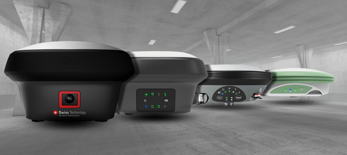 Leica GS07 - Lightweight and robust mid-range smart antenna.
The Leica GS07 is the mid-range GNSS smart antenna known for being lightweight whilst still extremely robust which is focussed on functionality to perform exactly how it is required. It ensures fast and reliable data capture with stakeout combined in an easy-to-use rover with 320 channels, multi-frequency and multi-constellation. The Leica GS07 also supports communication devices such as UHF radios which are fully integrated into the Leica CS20 field controller.
Leica Viva GS16 - Industry leading self-learning GNSS smart antenna.
The Leica Viva GS16 is a more powerful and compact, self-learning GNSS smart antenna. Operating with the leading RTK technology, the Leica GS16 adheres to the highest measurement standards utilising RTKplus which provide accurate positions by intelligently adapting to changing conditions by selecting the optimal signal, and global SmartLink if the local correction service is unavailable due to obstructions or lack of cellular coverage.
Leica GS18 T - Fastest and easiest-to-use GNSS RTK rover
The Leica GS18 T is the fastest and easiest-to-use GNSS RTK rover because there is no need to hold the pole vertical. This is due to the first true tilt compensation solution, an innovation that combines GNSS and inertial micro units (IMUs) which is immune to magnetic disturbances. With no calibration procedure or the need to watch and level the bubble, the Leica GS18 T increases productivity and saves time over conventional surveying practices.
Leica GS18 I - Versatile, survey-grade GNSS RTK rover with Visual Positioning
The latest addition the range is the new Leica GS18 I, an extremely versatile, GNSS RTK rover which has all the functionality of the Leica GS18 T in with the added enhancement of Visual Positioning. This advancement in technology provides surveying professionals with the ability to use a GNSS rover to measure difficult to access points with ease and accuracy. Sensor fusion of GNSS, a camera and IMU combine to create Visual Positioning technology, allowing the site to be captured in images and measure points from them, either in on-site or later in the office.
All of the Leica GNSS smart antennas come with the revolutionary Leica Captivate software for a fully immersive experience, turning complicated data into realistic 3D models. Through the simplicity of touch, the management of complex data is made very enjoyable and actionable. Touch screen technology and easy to use apps allow measured and design data to be seen in all dimensions.
Please see below the full comparison chart and download here.
Leica GS07 - Lightweight and robust mid-range smart antenna.
The Leica GS07 is the mid-range GNSS smart antenna known for being lightweight whilst still extremely robust which is focussed on functionality to perform exactly how it is required. It ensures fast and reliable data capture with stakeout combined in an easy-to-use rover with 320 channels, multi-frequency and multi-constellation. The Leica GS07 also supports communication devices such as UHF radios which are fully integrated into the Leica CS20 field controller.
Leica Viva GS16 - Industry leading self-learning GNSS smart antenna.
The Leica Viva GS16 is a more powerful and compact, self-learning GNSS smart antenna. Operating with the leading RTK technology, the Leica GS16 adheres to the highest measurement standards utilising RTKplus which provide accurate positions by intelligently adapting to changing conditions by selecting the optimal signal, and global SmartLink if the local correction service is unavailable due to obstructions or lack of cellular coverage.
Leica GS18 T - Fastest and easiest-to-use GNSS RTK rover
The Leica GS18 T is the fastest and easiest-to-use GNSS RTK rover because there is no need to hold the pole vertical. This is due to the first true tilt compensation solution, an innovation that combines GNSS and inertial micro units (IMUs) which is immune to magnetic disturbances. With no calibration procedure or the need to watch and level the bubble, the Leica GS18 T increases productivity and saves time over conventional surveying practices.
Leica GS18 I - Versatile, survey-grade GNSS RTK rover with Visual Positioning
The latest addition the range is the new Leica GS18 I, an extremely versatile, GNSS RTK rover which has all the functionality of the Leica GS18 T in with the added enhancement of Visual Positioning. This advancement in technology provides surveying professionals with the ability to use a GNSS rover to measure difficult to access points with ease and accuracy. Sensor fusion of GNSS, a camera and IMU combine to create Visual Positioning technology, allowing the site to be captured in images and measure points from them, either in on-site or later in the office.
All of the Leica GNSS smart antennas come with the revolutionary Leica Captivate software for a fully immersive experience, turning complicated data into realistic 3D models. Through the simplicity of touch, the management of complex data is made very enjoyable and actionable. Touch screen technology and easy to use apps allow measured and design data to be seen in all dimensions.
Please see below the full comparison chart and download here.