Ridge and Partners LLP is a multidiscipline Property and Construction Consultancy with over 650 employees working worldwide from 11 offices across the UK. In September 2019 their Geospatial team were commissioned by Oxford City Council to undertake a full laser scan survey and produce a Revit 3D Model of the Oxford Town Hall, a grade II* listed building in the centre of Oxford. Completed in 1897, Oxford Town Hall is a is Grade II* public building located in central Oxford, England and is both the venue for public meetings, entertainment, events and the seat of Oxford City Council.
Using Autodesk Revit, a BIM (Building Information Modelling) software that produces high-quality 3D architectural designs and documentation, the specialist Ridge team created a 3D model to integrate information from a 30-year planned maintenance report and condition survey, which had previously been carried out by a team of professional building surveyors from Ridge. There were some key challenges faced during the project which predominantly revolved around the amount of data being processed. As the town hall is a large historic building (7 floors, approximately 18,000m²) with a great deal of detail, more than 1800 colour scans from various scanners were needed to register into a complete point cloud.
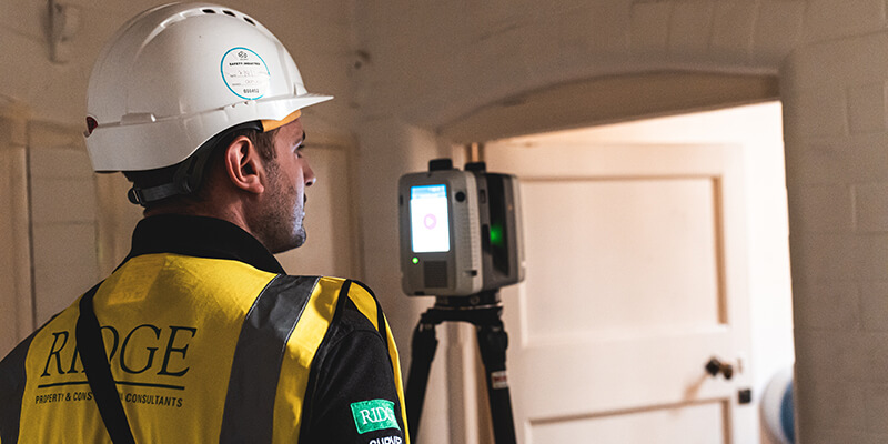 Ridge team scanning internal rooms of Oxford Town Hall, a grade II* listed building with a Leica RTC360 Laser Scanner
The city council required an accurate report and data on the current layout of the building, as much of their information was either outdated or inaccurate. The condition and maintenance information was to be integrated and easily accessible for asset maintenance by everyone, including the facilities team, and also an existing 3D BIM Ready model which could be used by design teams for any future planned work.
Ridge team scanning internal rooms of Oxford Town Hall, a grade II* listed building with a Leica RTC360 Laser Scanner
The city council required an accurate report and data on the current layout of the building, as much of their information was either outdated or inaccurate. The condition and maintenance information was to be integrated and easily accessible for asset maintenance by everyone, including the facilities team, and also an existing 3D BIM Ready model which could be used by design teams for any future planned work.
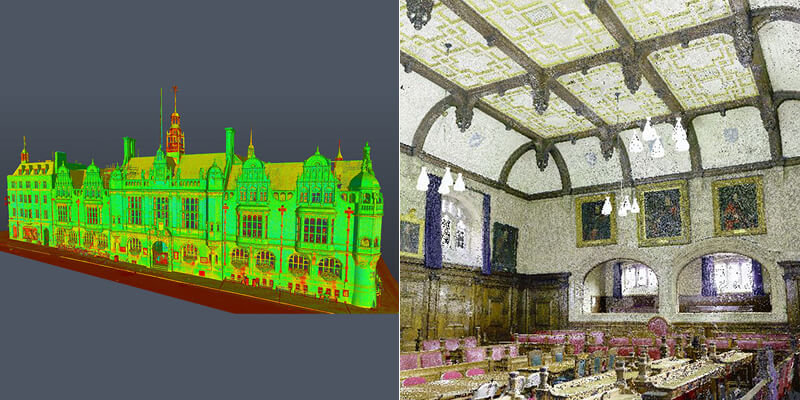 A full-colour external and internal Point Clouds of Oxford Town Hall created using a Leica P40 and RTC360 Laser Scanners.
The result was an accurately registered colour point cloud of the Oxford Town Hall which could be published in an Autodesk Recap format along with viewing capabilities for the client, (Jetstream). The point cloud would then be used to produce an accurate and highly detailed 3D Revit BIM-ready model of the building including the condition and maintenance information.
A full-colour external and internal Point Clouds of Oxford Town Hall created using a Leica P40 and RTC360 Laser Scanners.
The result was an accurately registered colour point cloud of the Oxford Town Hall which could be published in an Autodesk Recap format along with viewing capabilities for the client, (Jetstream). The point cloud would then be used to produce an accurate and highly detailed 3D Revit BIM-ready model of the building including the condition and maintenance information.
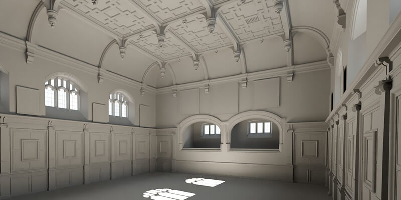 Autodesk Revit 3D model of internal room
Equipment Ridge and Partners LLP used on this project:
Autodesk Revit 3D model of internal room
Equipment Ridge and Partners LLP used on this project:
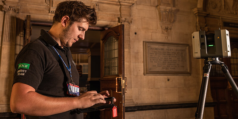 Further internal scanning with a Leica RTC360 Laser Scanner
With the use of a Leica Viva GS16 GNSS Smart Antenna, the Ridge team recorded a minimum of two control points to orientate the scan data to OS and a Leica TS16 Total Station provided orientation over control points gathered by the GPS and used to set up a control network. It was also used to pick targets to register the laser scan data. At the end of the survey, the captured raw scan data from both scanners were then processed in Leica Cyclone 3D and Leica Cyclone REGISTER 360, to then output as E57 files to bring into Autodesk Recap.
"I would highly recommend SCCS Survey Equipment who provided all of the equipment when we needed with it, with technical support on-site and in the office to help when processing data, which is invaluable on a project of this scale"
Tom Wheatcroft BA(Hons)
Architectural Technologist / Geospatial Surveyor
Further internal scanning with a Leica RTC360 Laser Scanner
With the use of a Leica Viva GS16 GNSS Smart Antenna, the Ridge team recorded a minimum of two control points to orientate the scan data to OS and a Leica TS16 Total Station provided orientation over control points gathered by the GPS and used to set up a control network. It was also used to pick targets to register the laser scan data. At the end of the survey, the captured raw scan data from both scanners were then processed in Leica Cyclone 3D and Leica Cyclone REGISTER 360, to then output as E57 files to bring into Autodesk Recap.
"I would highly recommend SCCS Survey Equipment who provided all of the equipment when we needed with it, with technical support on-site and in the office to help when processing data, which is invaluable on a project of this scale"
Tom Wheatcroft BA(Hons)
Architectural Technologist / Geospatial Surveyor
 Ridge and Partners LLP
>> Download the Case Study PDF
Ridge and Partners LLP
>> Download the Case Study PDF
Ridge team scanning internal rooms of Oxford Town Hall, a grade II* listed building with a Leica RTC360 Laser Scanner
The city council required an accurate report and data on the current layout of the building, as much of their information was either outdated or inaccurate. The condition and maintenance information was to be integrated and easily accessible for asset maintenance by everyone, including the facilities team, and also an existing 3D BIM Ready model which could be used by design teams for any future planned work.
A full-colour external and internal Point Clouds of Oxford Town Hall created using a Leica P40 and RTC360 Laser Scanners.
The result was an accurately registered colour point cloud of the Oxford Town Hall which could be published in an Autodesk Recap format along with viewing capabilities for the client, (Jetstream). The point cloud would then be used to produce an accurate and highly detailed 3D Revit BIM-ready model of the building including the condition and maintenance information.
Autodesk Revit 3D model of internal room
Equipment Ridge and Partners LLP used on this project:
- Leica ScanStation P40
- 2 x Leica RTC360 Laser Scanners
- Leica Viva GS16 GNSS Smart Antenna
- Leica Viva TS16 Total Station
Further internal scanning with a Leica RTC360 Laser Scanner
With the use of a Leica Viva GS16 GNSS Smart Antenna, the Ridge team recorded a minimum of two control points to orientate the scan data to OS and a Leica TS16 Total Station provided orientation over control points gathered by the GPS and used to set up a control network. It was also used to pick targets to register the laser scan data. At the end of the survey, the captured raw scan data from both scanners were then processed in Leica Cyclone 3D and Leica Cyclone REGISTER 360, to then output as E57 files to bring into Autodesk Recap.
"I would highly recommend SCCS Survey Equipment who provided all of the equipment when we needed with it, with technical support on-site and in the office to help when processing data, which is invaluable on a project of this scale"
Tom Wheatcroft BA(Hons)
Architectural Technologist / Geospatial Surveyor
Ridge and Partners LLP
>> Download the Case Study PDF