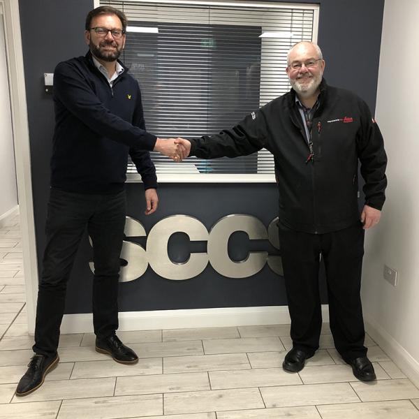
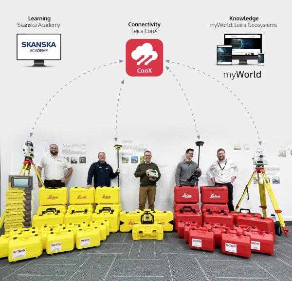
Latest News

  • Bentley Pointools v8i Upgrade Options Now Available

    Posted on February 15, 2013 by Curtis Woodward

    Bentley Pointools v8i Upgrade Options now available. Contact us for more information


    This post was posted in General Support

  • SCCS placement of the first order in the UK for Leica Geosystems' latest scanning technology the ScanStation P20.

    Posted on December 13, 2012 by Curtis Woodward


    Group managing director Paul MacArthur is pleased with the latest offering from Leica Geosystems stating that

    "We are excited about this new addition to our hire fleet. The specification is excellent with a low noise +/- 1mm at 100m, working range of -20C to +50C and 1 million points per second  all this from a time of flight instrument with a real time dual axis compensator and Class 1 invisible laser. We continue to make significant investment with technology  from Leica Geosystems because of their commitment to develop hardware and software solutions that consistently push the boundaries of 3D laser scanning."


    Tim Badley sales manager for Leica HDS products added

    "We are confident that the ScanStation P20 will secure our position within the market place and are delighted SCCS as our distributing partner for HDS products have endorsed our faith in this great new product."


    This post was posted in HDS Scanning, Headlines

  • Leica GPS1200 software update alert

    Posted on December 12, 2012 by Curtis Woodward

    The Leica GMX902, GX1230, ATX1230, GRX1200 and GPS900 (purchased between 2004 and 2006) have an issue with the tracking GPS (with measurement engine generation 2). We are working on it with the utmost priority and will provide a software solution most likely within the next 48 hours (until 12 Dec., noon, CET) . We will keep you informed on myWorld.


    Not affected are newer generation products using 3rd or 4th measurement engine generation (ME3, ME4) such as Leica GX1230 GG, GX1230+GNSS, GRX1200 GG, GRX1200+GNSS, GMX902 GG, GMX902 GNSSATX1230 GG and ATX1230+.


    This post was posted in GPS Information, Headlines

  • Ask the Cyclone Experts

    Posted on November 3, 2012 by Phil Marsh

    Ask the Cyclone experts - Everything you wanted to know but never knew who to ask

    You're already using Cyclone, but chances are you have questions about specific application tools and processes. How do you achieve a smooth fly-through animation? Can you extract part of a scan and transpose it somewhere else within that scan? How can you optimize your preference settings to achieve what you are trying to accomplish? These Cyclone experts provide answers to common (and not so common) questions, providing instructions and screen shots to help you execute tasks step by step.

    Learn how to:

    • Create smooth fly-through animations
    • Clip out a section of a scan and move it to another location
    • Trace out curb and gutter
    • Move objects using snapping
    • … and much more

    Download Now 


    This post was posted in HDS Scanning and was tagged with General Support, Training, HDS Software, Webinar, Cyclone, SPAR Point Group

  • 3DReshaper Version 7.1 (beta version)

    Posted on November 1, 2012 by Phil Marsh

    A new release of 3DReshaper is now available in beta version from the TechnoDigit web site.

    http://www.technodigit.com/fr1/Fr_download.htm


    This post was posted in HDS Scanning and was tagged with General Support, HDS Software, 3DReshaper, Technodigit

  • New Tactics for Scanning/Modeling in Hazardous Conditions

    Posted on October 30, 2012 by Phil Marsh

    Free ClearEdge3D/SPAR Point Group Webinar
    New Tactics for Scanning/Modeling in HazardousRegister Today 
          Conditions: Case Studies by Ramboll Oil
               and Kiewit Power
    Wednesday November 7, 2pm - 3pm EST 

    Presented By:  

     Jonathan Beatty

    Project Manager
    Kiewit Power
     
      
    Robert Greenhalgh
    Scanning Manager
    Ramboll Oil
     
    Kevin Williams
    Founder & Chief Scientist
    ClearEdge3D, Inc. 
     
    Moderated By:


    Sam Pfeifle

    Editor
    SPAR Point Group


    ClearEdge 3D

    Including the first public demo of
    EdgeWise Plant 4.0
    Live Webinar - Join Us!
    Wednesday November 7, 2012
    2pm-3pm EST

    Time is of the essence--especially when scanning a "hot" room at a live nuclear plant or documenting an offshore platform in a North Sea gale. The goal is to get in, get out with complete data and get it modeled quickly.

    Please join us for a special presentation from two large engineering firms, Ramboll Oil and Kiewit Power who have beta-tested EdgeWise Plant 4.0 under the most demanding conditions.

    You'll get a first-ever look at ClearEdge3D's new EdgeWise Plant 4.0 software which offers major enhancements including valve & flange extraction, a new point cloud visualization engine that supports billions of points, a new demolition tool and much more.

    Jonathan Beatty with Kiewit Power, Robert Greenhalgh with Ramboll Oil, and Kevin Williams with ClearEdge3D will discuss the following:

    •  What are the unique project challenges in modeling as-built, "hot" nuclear facilities and exposed offshore rigs?
    • Best practices that radically speed the collection and modeling workflow
    • How a "weak link" in the hardware/software chain nearly crippled a project (this one will surprise you!)
    • How the benefits far outweigh the risks of implementing automation into your modeling projects

       Register Today  Last month, 344 of your colleagues/competitors registered for ClearEdge3D's webinar, so don't delay.  Click the button, sign-up and learn! 
     

    www.clearedge3d.com


    This post was posted in HDS Scanning and was tagged with Training, Webinar, ClearEdge3D, EdgeWise Plant

  • Bentley Pointools V8i - FAQ

    Posted on October 24, 2012 by Phil Marsh

    Frequentley Asked Questions


    1. Q. What products are now available from Bentley under the Pointools brand name?

    A. Three products are available; Bentley Pointools and two free iWare apps, Bentley Pointools View, and Bentley Pointools PODcreator.

    2. Q. Which, if any, Pointools products have been discontinued?
    A. Pointools Edit, Pointools ViewPro, and Pointools Suite are discontinued as of October 15, 2012. The Pointools plug-in products for Rhino and SketchUp will be discontinued December 31, 2012. The Pointools plug-in for AutoCAD will be repackaged to ship/work with ProjectWise Point-cloud Streaming Service.
     
    3. Q. How do I upgrade to Bentley Pointools?
    A. All the information you need can be found by emailing our HDS team on hds@sccssurvey.co.uk. If you upgrade now to BentleyPointools, you will be able to take advantage of new capabilities such as point cloud differencing and clash detection, which will be available before the end of 2012, at no extra product cost.
     
     4. Q. Is Bentley Pointools available under the Enterprise License Subscription (ELS)?
    A. Yes.
     
    5. Q. How can I purchase Bentley Pointools?
    A. You can purchase Bentley Pointools through SCCS by contacting hds@sccssurvey.co.uk
     
    6. Q. Can Bentley Pointools be used in industries other than those that are infrastructure related (e.g. forensics, heritage, security/defense etc.)?
    A. Yes.
     
    7. Q. How will I get access to future releases of Bentley Pointools?
    A. Any user who subscribes to Bentley’s SELECT program will have immediate access to new releases of Bentley Pointools at no extra charge. For more information about the SELECT program contact us on hds@sccssurvey.co.uk.
      
    8. Q. What other products does Bentley offer that support the viewing, visualization, manipulation, processing, and streaming of point clouds?
    A. Bentley offers a wide range of products that support point clouds. Apart from the three Pointools products/apps (Bentley Pointools, Bentley Pointools View, and Bentley Pointools PODcreator), Bentley supports point clouds in MicroStation and MicroStation-based products. Bentley offers Bentley Descartes for the advanced processing of point clouds in MicroStation workflows, and ProjectWise Point-cloud Streaming Service supports the streaming of point clouds from the server to the desktop.
        
    9. Q. In which countries can I purchase Bentley Pointools?
    A. In all countries as SCCS do international sales.
     
    10. Q. Is Bentley Pointools available in languages other than English?
    A. No.
     
    11. Q. Where can I get involved in an online forum about Bentley Pointools and point clouds?
    A. For the time being please visit www.pointools.com/forum. Over time, a forum will be created on Be Communities on www.bentley.com.
      
    12. Q. How do I submit requests for technical support?
    A. For Bentley Pointools please submit requests through http://selectservices.bentley.com/en-US/.


    This post was posted in HDS Scanning and was tagged with HDS, General Support, HDS Software, Software, Bentley, Pointools

  • New Leica Laser Scanner: Leica ScanStation P20

    Posted on October 9, 2012 by Phil Marsh

    Leica ScanStation P20: Three World’s Firsts in a Ultra-High Speed Laser Scanner to Deliver Unprecedented 3D Point Quality and Productivity

    Image

    Leica ScanStation P20 DATA 1012 795781 en LR.pdf_c564822a1O.pdf 
    (Heerbrugg/Switzerland and Hanover/Germany, 9th October 2012) - Leica Geosystems today announces the Leica ScanStation P20, bringing unprecedented performance to ultra-high speed laser scanning. Developed and manufactured by industry pioneer and leader, the Leica ScanStation P20 provides three world’s firsts in a compact terrestrial laser scanner: Onboard Check & Adjust functionality, sub-millimeter range noise at 120 m, and modern Waveform Digitizing (WFD) technology delivering 1 million points per second.

    As the pioneers of developing terrestrial laser scanners, Leica Geosystems has years of experience and deploys state-of-the-art technology to deliver the best quality. The Leica ScanStation P20 uses an optimal combination of angular and range measurements to provide unrivaled 3D point quality and product reliability.

    Certainty Matters - First Laser Scanner with Check & Adjust Functionality
    Leica ScanStation P20 includes an onboard Check & Adjust routine that lets users perform an electronic field check and adjustment of the instrument to ensure an optimally performing scanner.

    Productivity Matters – First Scanner with Lowest Range Noise and Waveform Digitizing (WFD)
    Leica ScanStation P20 sets new standards in laser scan data quality thanks to a combination of highly accurate, low-noise angular and range measurements. Achieving 1 million points per second scan speed plus sub-millimeter range noise – even out to 120m – is based on an innovative combination of time-of-flight range measurement and modern Waveform Digitizing (WFD) technologies. Leica ScanStation P20 is also an eye-safe class 1 laser instrument.

    Ruggedness Matters - Outstanding Environmental Specifications
    Leica ScanStation P20 is designed to master demanding environments. Working in temperatures from -20ºC to +50ºC, and with IP54 protection, the Leica ScanStation P20 can be deployed for all applications, even in extreme conditions.

    A Complete Solution - Leica Cyclone v8.0 and Leica CloudWorx Software Packages
    Simultaneous with the release of Leica ScanStation P20, companion Leica Cyclone v8.0 and Leica CloudWorx office software packages are updated to support the new scanner and provide optimal workflows for converting point clouds of reality into final client deliverables.

    Availability - The Leica ScanStation P20 is planned to be available later this year. Ordering information is available from Leica Geosystems and SCCS representatives.

    For more information please email: hds@sccssurvey.co.uk

    Leica ScanStation P20 - Main product features and benefits:

    Image
    Based on time-of-flight technology enhanced by Waveform Digitising (WFD) the ScanStation P20 measures with a scan rate of up to 1 mio pts/sec at a maximum range of 120m using an eye-safe class 1 laser.
    Image
    The combination of low noise range measurements in combination with highly accurate angular encoders and a survey-grade dual axis tilt compensator delivers highest data
    quality.

    Image
    An operating temperature range from -20°C to +50°C and an IP54 Ingress Protection rating for extended use at harsh environmental conditions.
    Image
    As an industry first in terrestrial laser scanning the ScanStation P20 comes with an onboard ‘Check & Adjust’ routine to determine instrument parameters in the field instead of returning the instrument to a service centre for re-calibration.

    SCCS SURVEY LTD l SALES, HIRE & SUPPORT l HDS LASER SCANNING
    T: 01480 404888 l M: 07540 201383 l E: hds@sccssurvey.co.uk l W: www.sccsurvey.co.uk l B: SCCS Blog

    This post was posted in HDS Scanning and was tagged with HDS, Laser Scanning, Leica, General Support, Training, HDS Hire, HDS Support, P20, ScanStation P20

  • ATR measurements when hand-booking

    Posted on October 8, 2012 by Administrator

    Automatic aiming (ATR)

    Description

    Automatic aiming is the function which recognises and measures the position of a prism using a CCD array. A laser beam is transmitted and the reflected beam is received by the built-in CCD array. The position of the reflected spot with respect to the centre of the CCD is computed. These automatic aiming offsets are used to correct the horizontal and vertical angles. The automatic aiming offsets are also used to control the motors which turn the instrument to centre the crosshairs to the prism. In order to minimise the time for measuring, the crosshairs are not moved to the exact centre of the prism. The automatic aiming offset can be up to 500 cc depending on selected Measure mode. The automatic aiming function measures the offsets between the crosshairs and prism centre and corrects the horizontal and vertical angles accordingly. Therefore the horizontal and vertical angles are measured to the prism-centre, even if the crosshairs are not aimed precisely at the centre of the prism. Motorised instruments can be equipped with automatic aiming.

    For Target aiming: Automatic the instrument can find a static prism and measure a distance once Meas or Dist is pressed. The instrument does not follow a moving prism. The crosshairs of the telescope may not fully coincide with the centre of the prism when viewed through the telescope. The remaining automatic aiming offsets for the horizontal and vertical angles are measured by the automatic aiming function and applied to the measured and displayed angles.


    This post was posted in TPS News & Support

  • GPS1200 – Auto-Logging for fast kinematic surveys (Spot Levels/Roads)

    Posted on October 8, 2012 by Administrator

    When the kit is mounted on a vehicle for faster data acquisition, for example spot levels across sand flats, it is not practical to MEAS every point by pressing F1.

    Instead, go into Survey, press the SHIFT button, then F2 CONF to access SURVEY Configuration. Set the ‘Log Auto Pts’ to Yes, and configure as appropriate.

    Configuring Auto Points

    Main Menu:

    Survey.

    Press the SHIFT button, then F2 CONF to access SURVEY Configuration.


    File (Pts Only)

    Logs auto point to a measurement file (this is the same as a DBX job, found in the DBX folder). Point logging at up to 20 Hz. Coding and logging of offset points is not possible. Points cannot be displayed in MapView or output via format files – you must Import Raw data into LGO as seen below, then export a CSV or DXF from there.

    At 60mph you will get a point every 1.34m!


    DBX (Pnts & Codes)

    Logs auto points to the DBX. Point logging at up to 1 Hz. Coding and logging of offset points is possible. Points can be displayed in MapView or output via format files.


    This post was posted in GPS News & Support

Items 1 to 10 of 171 total

Page:
  1. 1
  2. 2
  3. 3
  4. 4
  5. 5
  6. ...
  7. 18

SCCS Hire

Need an instrument quickly?

At SCCS we have a large comprehensive survey equipment hire fleet, fully maintained by factory trained staff. We aim to offer next day delivery service and same day delivery service wherever possible. If there is a hire instrument you require that is not listed please do not hesitate to call us and we will do our best to help you. To hire any of our surveying equipment please contact us:

Tel: 01480 404888
Email: sccs@sccssurvey.co.uk

Click here for details

Our new catalogue

Click here to view
If you would like us to send you a printed version please contact us:

Tel: 01480 404888
Email: sccs@sccssurvey.co.uk